Tornado watch issued for 3 states as multiday severe weather, flooding threats begin to unfold

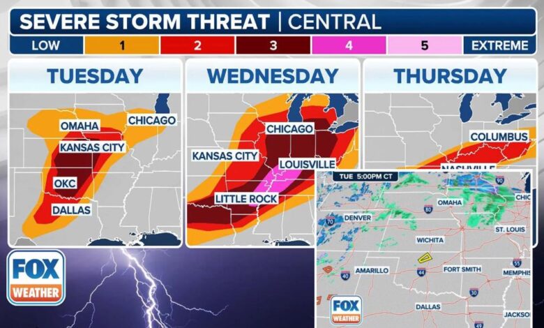
Severe weather is once again on the horizon for the central United States, with damaging winds, large hail, and tornadoes expected to hit starting late Tuesday and continuing through Thursday. At the same time, there is a significant risk of extreme flash flooding in the Mississippi and Ohio valleys this week, with some areas potentially seeing up to a foot of rain.
A strong storm system is currently strengthening over the western U.S., which will send a cold front and warm front into the central Plains and Midwest. Severe thunderstorms are expected to develop from Texas to Illinois by Tuesday evening.
The National Weather Service has issued weather alerts for the central U.S. as storms are expected to develop through Tuesday evening. The latest radar, warnings, and watches should be closely monitored.
While storms struggled to form during the day on Tuesday due to an atmospheric lid inhibiting thunderstorm development, isolated storms could develop along the dryline in Oklahoma and Texas, bringing a low chance of hail or strong wind gusts. The Storm Prediction Center has expanded the Level 3 risk zone to include the Kansas City metro area and adjacent areas.
On Wednesday, a significant severe weather threat is anticipated from Lower Michigan and the Ohio Valley southwestward through the mid-South and southern Plains. The Storm Prediction Center has upgraded the severe weather threat to a Level 4 risk zone, including major cities like Memphis, Clarksville, and Jackson.
The severe weather threat will continue into Thursday as the cold front stalls from the Mississippi and Ohio valleys into the southern Plains. Daytime heating and high humidity will fuel another round of severe storms, with damaging winds, large hail, and tornadoes possible.
In addition to the severe weather threat, there is also a growing risk of extensive flash flooding in the Mississippi and Ohio valleys this week. Repeated storms moving over the same areas could lead to significant rainfall totals, potentially approaching a foot in some areas.
The FOX Forecast Center is also monitoring a winter weather threat in parts of the Dakotas, northern Minnesota, and the Upper Peninsula of Michigan, with the potential for 4-plus inches of snow and near-blizzard conditions with blowing snow.
Overall, weather alerts have been issued across the central U.S. as storms develop and the potential for severe weather and flash flooding continues throughout the week. It is important to stay informed and prepared for changing weather conditions.


